

The biology and geology of the Mendocino Coast
Mendocino Coast geology and biology
The Mendocino Coast in northern California is home to spectacular, rugged seashores. The bedrock of the northern Coast Ranges is dominated by the Franciscan complex, an extremely varied jumble of sedimentary and metamorphic rocks known as a mélange. The erosion of such mixed rock produces an irregular coastline, with coves and beaches where soft rocks such as marine shale or sandstone has been worn away, and headlands projecting where harder rocks like granite and basalt are exposed.
Winter storms approach the exposed northern coast from the open ocean, bringing with them powerful wind-generated waves. In addition, normal wind swells, longshore currents, and occasional tsunamis also strike the north coast with full force. These actions continue to form the rugged shoreline.
The Mendocino Coast is relatively young and is still actively forming. Landforms such as sea caves, stacks, and arches are common. When the roof of a sea cave falls, a bowl-shaped formation results. Other portions of the coast have rocks that look like bowling balls and gargoyles! Additionally, marine terraces reveal evidence of the history of uplift and erosion.
A sea arch is a natural opening eroded out of a cliff face by the action of wind and water. Sea stacks represent remnants of sea arches that have collapsed as a consequence of a continued wave erosion.
Because the northern California coast faces the Pacific Ocean basin, where strong earthquakes occur frequently, tsunamis pose an additional hazard. Tsunamis can travel thousands of miles from their source, so even earthquakes in Japan or South America have potential to affect the northern California coast. Coastal development is commonly at risk because of cliff retreat and mass wasting events that undermine support for structures.
In fact you’ll see Tsunami warning signs as you meander along Highway 1.
It’s not Andreas’ Fault
Along the length of most of California, the San Andreas Fault defines the boundary between the Pacific Plate to the west and the North American Plate to the east. Along the fault line, the Pacific Plate slides horizontally in a north-northwesterly direction with respect to North America. In Mendocino County the San Andreas Fault is located pretty much right at the coastline. The San Andreas fault runs offshore near the town of Point Arena to Cape Mendocino, where the San Andreas Fault ends at the "Triple Junction.” The Triple Junction is where the American Plate, Pacific Plate and the Gorda Plate meet. North of the Cape the off-shore Gorda Plate glides under the North American Plate in what is called a subduction zone. This movement is what forms the northern Coast Range.
In northern California, there is almost no seismicity on the San Andreas Fault. The notable exception is the 1906 earthquake. Instead, the majority of the earthquakes occur on two faults (the Maacama and the Bartlett Springs) that are parallel to, and 30-50 miles east of, the San Andreas. These faults are part of the greater San Andreas system, and are capable of generating large magnitude earthquakes.
The Geology of Vegetation - Marine Terraces
The mountains of the northern Coast Ranges are still rising due to continued plate movement at the Triple Junction. In the Mendocino area the land is rising faster than the sea, resulting in marine terraces or steps. Because of continual uplift the terraces are elevated above sea level giving a staircase-like appearance. The result is an “ecological staircase.” Each terrace, or step, represents approximately 100,000 years and possesses a distinctive vegetation type. A trail leads through these steps at Jughandle State Reserve. From the 2.5 mile trail, five terraces and approximately 650 feet of elevation increase can be viewed. The trail spotlights the different ecosystems from coastal scrub and grassland; through pine, redwood, fir, and spruce forests; then through Mendocino (pygmy) cypress groves; up to pine, fir, and Fort Bragg manzanita woodlands; and finally the oldest, highest terrace represented by Douglas fir forest.
The steep northern Coast Range intensifies rainfall due to the orographic effect. As Pacific storms hit the coast, air masses are forced up the steep mountainside. As the air rises, it cools and water vapor condenses and concentrates rain on the coastal side of mountains.
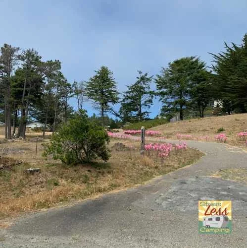
Naked Ladies
Amaryllis Belladonna are also known as naked ladies, because when they bloom in mid-August, the leaves of this pretty, pink lily have already died back. Mendocino and the northern California coast are certainly not the only place to find naked ladies; they are actually native to south Africa. Still, the Mendocino Coast does have a whole bunch of them, and they are so pretty! They thrive in the region’s rocky ground and are quite drought-tolerant.
